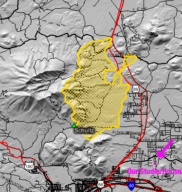
 This is a map of the current perimeter of the Schultz Fire (6/23/10). I borrowed it from a federal interagency website. Yellow is the burn area, the crater to the left of the burn area is the “Inner Basin” of the San Francisco Peaks. Notice our Studio/House in the bottom right.
The fire is nearing a couple of our favorite spots, Lockett Meadow and the Inner Basin, a major part of the Flagstaff watershed. However, firefighters may have a little help from mother nature in the form of aspen trees. Aspens are high in moisture and have a thin layer of bark, which makes them less flammable than other species. A wind-driven fire still burns through aspens, but when they are on the edge of a fire and not the front, they tend to stop or slow down a fire in their direction.
This is my way of saying there is hope! Another positive is that fires naturally burn in what we call a “mosaic,” so the forest within a “burn area” (above in yellow) burns at varying intensity or maybe doesn’t burn at all. A low or even a moderate severity burn can be a very healthy thing for our forest.
It has been a sad week for us watching our beloved mountains burn, but there are still beautiful areas that remain for us to photograph on our workshops! Again, we send thanks and positive energy to all those working to keep the fire out of our watershed! And my apologies for my longest post ever!
Ciao…
Thank you for the post, Barb. I’ve been thinking about you guys and praying that the fire in the mountains you love so much would be contained quickly and, of course, that you are all safe.
Our positive energy and meditations go out to all in the area…especially you two. As for me, I appreciate the update, no matter how long. Thanks.
Thanks for keeping us informed. Everything in moderation, I say. I wish it could just be turned off now. I am sure enough good has been done. But it is great to continue to see the positive side of things! Sending well wishes that all critters big and small in the area stay safe.